The Industrial Waterfront Study will receive a Public Hearing at the Planning Commission meeting this week on Wednesday, February 14, 2024. The goal of this document is to understand the current conditions along the Southern Branch of the Elizabeth River and determine preferred future land uses based and identify the range of adaptation strategies that can increase the resilience of coastal and riverine areas and increase opportunities for economic development.
In my review, I think the Planning Department did an excellent job of presenting a balanced approach that prioritizes space for industrial businesses critical to the local economy and tax base while identifying a range of adaptation strategies that can increase the resilience of coastal and riverine areas to address sea level rise, increasing stormwater flooding, and recurrent tidal inundation. (The text in bold is taken directly from the Draft Study which can be found at https://www.cityofchesapeake.net/582/Industrial-Waterfront-Study).
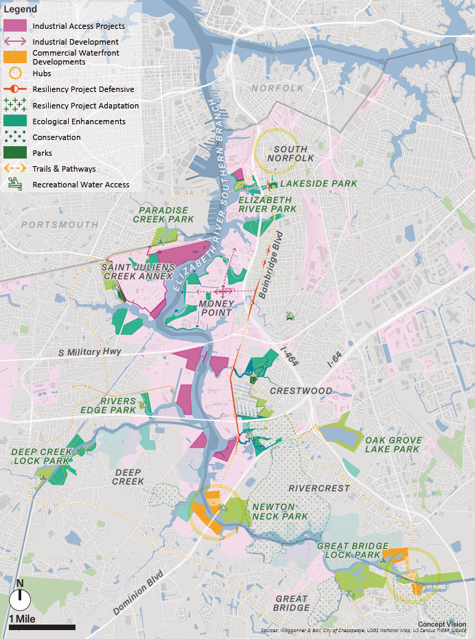
The plan takes the approach of consolidating industrial sites to undeveloped areas along the deep water channel north of the Veteran’s Bridge and removing industrial facilities from residential neighborhoods south of there to lower the overall nuisance factor created by industry and create recreation and conservation zones in the creeks and naturalized areas of the river as depicted on the map on page 63. It sets goals of conserving existing wetlands, and enhancing ecological function, through living shorelines, constructed wetlands, and green infrastructure throughout the watershed can further offset industrial impacts.
Recommendations in the plan include:
- Tree planting to create green buffers between industrial areas and less intensely developed parts of the City and along waterways to create riparian buffers as required by the Chesapeake Bay Preservation Area.
- Creating a tree banking system to allow for industrial facilities to contribute to varied and flexible tree planting strategies, such as creating buffer zones near residential neighborhoods, mitigating stormwater runoff, reducing erosion, and creating shade along pedestrian corridors.
- Resilience and adaption efforts to identify vulnerable areas and work with local communities to create adaptation strategies such as raising roads, flood proofing critical infrastructure, and facilitating buy-outs; improve stormwater management practices through green infrastructure like bioswales, rain gardens, and stormwater parks; prioritize development on higher ground; and where appropriate, build defensive infrastructure where feasible, raising roads and implementing tides gates to mitigate flood risk and preserve access to industrial sites and neighborhoods.
- Slowing stormwater runoff through green infrastructure and increased tree canopy, improve the ability to store excess runoff and tidal flows in detention and retention features integrated into the landscape and public spaces, and create buffer zones along the water’s edge with living shorelines, marshes, and reefs.
- Softening the hard edges along the industrial waterfront to improve water quality by turning concrete and rip rap lined shores into regraded wetland edges can filter pollutants out of the water and create habitat for marine life.
- Goals to increase recreational access to water with piers, kayak launches, and new waterfront parks, create a loop trail connecting parks, public spaces, and waterfront areas, create multi-functional parks that store stormwater, reduce flooding, and improve water quality in the Elizabeth River,
- Goals to increase neighborhood walkability connecting residential areas, commercial corridors, and local parks.
- Concept of creating a loop trail, as depicted on page 74, complete with bike lanes, walking trails, boardwalks, and pedestrian paths linking together communities, parks, and waterfront access across the watershed.
- Plans to raise Bainbridge Boulevard to create a multifunctional flood defense line, including bike paths, street tree planting, and where appropriate, living shorelines, in the roadway redesign.
- Goal to integrate the 17 existing Watershed Drainage Plans with public space goals, land use decisions and potential defensive measures maximizes benefits and unlock varied sources of potential funding.
- Creating stormwater parks can integrate drainage infrastructure projects with public space goals and vice versa.
- Brownfield remediation design goals to identify brownfields within the city and work to apply for state and federal grant funding, to facilitate and support land revitalization; assist with environmental assessment and clean-up.
- Design goals create vegetative buffers between residential areas and industrial properties) and along the shorelines of the industrial waterfront, including tree planting and adjusting tree ordinances to encourage connected, dense tree and native planting buffers.
Some of the development scenarios documented include:
- turning the Port of Virginia property along Jones Creek in South Norfolk into a Wetlands Mitigation Site with boardwalks and trails
- creating a living shoreline and buffer zone along the Belharbor Site, if it is developed into an industrial site
- incorporating public waterfront access into the St. Juliens facility
- expanding the living shorelines and green infrastructure at Money Point
- conserving green space and provide waterfront access along the power lines corridor at the old power plant.
- implementing green infrastructure projects in Crestwood including a stormwater park along Newton Creek, blueway along Hodges Creek and other green infrastructure
- developing trails in Newton Neck Park
- connecting trails in Bells Mill Park with Great Bridge Bridge and to the Municipal Center