Trails and Connectivity Plan


The City is working on wrapping up its work on a Trails and Connectivity Plan.  A draft document is expected in mid-July with a tentative date for the Planning Commission in August, and then on to the City Council for final approval a few months later.  At the last Open House, the City shared a detailed draft Network Map and conceptual drawing of Separated Mulit-use Paths, on-road Buffer Bike Lanes, Bike Boulevards, etc.    The Open House material can be viewed at Chesapeake Trails and Connectivity Plan | Chesapeake, VA (cityofchesapeake.net)

But even the more modest implementation of such plans along existing rights-of-way can take many years, and sometimes decades, to become reality.  These projects almost always require years of planning, right-of-way and easement acquisition, application for grants and appropriation of substantial funding, bidding out of projects, design, and finally construction.   The Western Branch Rail to Trail project is a noteworthy example; this 2.5 mile trail was identified as a priority in 2017 (perhaps earlier); as of today, about 1 mile is constructed, a second mile is targeted to start construction this year, and the critical final 1/2 mile to connect with Suffolk is expected to complete design before the fall of 2025.

The Plan does need to include these big projects.  They represent the desired future state and we need to these plans in order to fund, design and build these projects.  But these long-term projects have do not directly help citizens who need or want to use alternative transportation methods today

I believe we also need an incremental approach where we deliver value to our citizens in the near term, e.g. within 1 to 3 years.  The Plan must address tactical projects that are relatively low cost and deliver results every year. Some of the tactical improvements to make our streets safe for pedestrians, bicyclists, and all users of our streets include:
  • Crosswalk Maintenance - repaint fading crosswalks using latest standards for high-visibility such as "zebra striping".    
  • Curb ramps at crosswalks should be properly aligned with crosswalks to allow clear passage without making bicycles - and wheelchair and other wheeled devices - have to negotiate hairpin turns.  
  • Identify existing bike routes across city - this includes existing multi-use paths (e.g. Scenic Parkway) , existing dual-use (widened) sidewalks (e.g. Volvo Parkway near Summit Point), on-road bike paths (e.g. Butts Station Road), and also low traffic side streets that can serve as route connections (e.g. Lilac Ave, Wingfield Ave, Border Road, Liberty St., Ohio St., Chesapeake Ave, Rodgers St.).  
  • Provide maps, install signage, and encourage use of these existing routes.  We have lots of existing routes that citizens do not know about.  
  • Properly maintain sidewalks to eliminate trip hazards and other obstacles 
  • Promote safety education for both automobile drivers - awareness of bicyclists, distracted driver prevention, safe passing of bicycles (change lanes, 3' law), etc. - and bicyclists - rules of the road, proper bicycle equipment and maintenance, etc.
  • Adjust traffic light optical sensor sensitivity to recognize bicyclists waiting at red lights
  • Implement bicycle green pavement markings at key intersections.

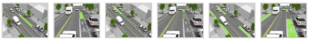
    Graphic from National Association of City Transportation Officials (nacto.org)

  • Provide bicycle racks/parking areas at all City facilities and encourage private business to install the same.
  • Identify locations that require new crosswalks, especially near bus stops and near parks, and install such crosswalks. Bus riders inevitably need to cross a major street reach the bus stop either coming or going; too often transit users need to make this street crossing where there is no crosswalk.  Likewise, achieving the goal of 10-minute walk to parks requires ways to safely cross major streets  
  • Set a goal to develop a Ride-Share Policy
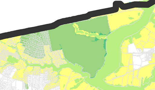


2024 Conservation Scorecard


The Virginia League of Conservation Voters has released their 2024 Conservation Scorecard for this year's General Assembly.  It reviews various environment related bills that were considered in Richmond this year and how legislators voted on them - and whether they were signed into law by the Governor.  You can see the full scorecard at 2024-Conservation-Scorecard_Revised.pdf (valcv.org)

Bill that passed that would affect us locally - and were signed by the Governor include:

  • HB1458 Establishing an Office of Resiliency
  • HB746/SB565 Savings Achieved via Efficiency (SAVE) Act - ensuring electric utilities continue to provide energy efficiency programs to customers
  • HB106/SB253 Expanding Shared Solar Programs - expanding Dominion's shared solar program from 200 MW to 350 MW
  • SB25/HB199 - State Funding for Brownfield Renewable Energy Grant Fund - however no state funds were appropriated in the budget to help get this program going
  • SB508 - Accelerating Geothermal Energy Development
  • HB862 - Building a Modern, Efficient Electric Grid
  • HB285 Building Better Bus Stop
  • HB985 Prohibiting Toxic Pavement Sealant Use
  • HB673 Prioritizing At-Risk Communities in Resiliency Funding Decisions - although an amendment from the Governor removed the preference for nature-based solutions in the bill
And bills that were ultimately vetoed by the Governor - and thus do not become the law of the Commonwealth
  • HB1100 Preserving Tree Canopy Statewide
  • HB47/SB306 Raising Awareness About Invasive Plants
  • SB720 Establishing a Clean Energy Innovation Bank - to access federal clean energy investment funds
  • HB333 Empowering the Virginia Council on Environmental Justice
  • SB595/HB208 Adopting Local Healthy Community Strategies
  • HB1088 Improving Environmental Literacy
  • HB 405 Identifying EV Charging Infrastructure Needs Study
  • HB949 Regulating Aboveground Chemical Storage Tanks
In the "Compromise Budget" provided some important environmental funding including $3.75 million in state matching funds to go toward the U.S. Army Corps of Engineers’ clean-up of Money Point on the Elizabeth River in Chesapeake, language moving up the effective date of the polystyrene “styrofoam” ban to 2025 for chains and 2026 for smaller restaurants, $100 million for the Community Flood Preparedness Fund (CFPF) to fund projects across the state that protect homes and businesses from flooding, in lieu of revenue Virginia’s forgoing by not being in the Regional Greenhouse Gas Initiative, and $150 million towards three different programs, including the Enterprise Zone Grant Program, which can go towards parking lot and rooftop solar deployment.   See the Scorecard for all the budget details.

Virginia LCV also scores how each legislator voted on environmental issues.  For representatives covering the City of Chesapeake the scores they gave were:

Delegate Bonita Anthony - 100%
Delegate Cliff Hayes - 100%
Delegate Jay Leftwich - 33%
Delegate Baxter Ennis - 48%
Delegate Nadarius Clark - 100%

Senator Christie Craig - 24%
Senator Louise Lucas - 95%
Senator Emily Jordan - 29%

See the document for details on which bills they voted for and against.

June Newsletter


In this edition
- Green Drinks Chesapeake - Wednesday, June 26
- Proposed changes to Chesapeake Bay Preservation Area in Chesapeake
- Comp Plan Open Houses
- City Council Meeting - June 11 (Single Member Voting Districts & Recycling Referendums)
- June Planning Commission Meeting - June 12
- Agricultural Subdivision Ordinance
- Action Alerts
- More Upcoming Events
- In the News

Green Drinks Chesapeake - Wednesday, June 26

Our next meeting will be Wednesday, June 26, 2024 from 6 pm to 8 pm at YNot Italian in Greenbrier, 1036 Volvo Parkway, Suite 7 Chesapeake, VA, 23320.

Among other topics we'll discuss drafting a sign-on letter to the City Council about Planning Documents that are being prepared, including the Greenbrier Area Plan and the Trails and Connectivity Plan.

Please note the day change to Wednesday. The City Council meeting on Tuesday the 25th will be considering the proposed CBPA changes, so we wanted to keep that day clear to attend the City Council meeting. There have been several City Council meetings of interest on the 4th Tuesday in recent months, so we will consider moving the Green Drinks to the 4th Wednesday permanently.

What is Green Drinks?  Green Drinks is mostly for people working on environmental issues, but anyone can come -- people from environment groups, business, government, academia, and as individuals. There is no 'us and them'. Green Drinks is a chance to mingle, share insights, inspire and delight each other. Come out and order some food or a drink (each participant pays for their own drinks and food; if drinking, please do so responsibly!) and join the conversation. Please do share the invite with others who may be interested. 

Proposed changes to Chesapeake Bay Preservation Area in Chesapeake

Areas affected in Fernwood Farms/Riverwalk
On Friday, May 31st, several of us met with the Planning Department to discuss the proposed CBPA District boundary changes in Chesapeake.  In attendance were representatives from the Friends of Indian River, Fernwood Farms Civic League, and the Chesapeake Bay Foundation.   Representatives from Wetlands Watch wanted to attend the meeting but were unavoidably unavailable that day.  

The Planning Department provided an informative briefing on the process they followed for the CBPA changes.  We discussed multiple areas of concern and the Planning Department said they would address these areas.

The removal of the forested wetlands by Fernwood Farms continues to be one of our areas of greatest concern, but not the only area. Read more on the items we asked the City to address at http://www.greeningchesapeake.com/2024/06/cbpa-update.html

The CBPA changes are scheduled to go back to City Council for decision on Tuesday, June 25.

Comp Plan Open Houses

The Greenbrier Area Plan Open House was on May 22.  The charts presented can be seen at https://www.cityofchesapeake.net/3100/Greenbrier-Area-Plan.  

The Trails and Connectivity Plan Open House was on June 3.  The charts presented will be posted soon at https://www.cityofchesapeake.net/3233/Chesapeake-Trails-and-Connectivity-Plan

Comments on these plans can be sent to planning@cityofchesapeake.net

The Planning Department is continuing with the next round of public Community Open Houses. Upcoming meetings include:

  • June 10 from 5:00 - 6:30 p.m., Chesapeake Conference Center
  • June 13 from 5:00 - 6:30 p.m., Fire Station #7, 3329 South Battlefield Blvd.
  • June 17 from 5:00 - 6:30 p.m., Chesapeake Lifestyle Center

See https://www.cityofchesapeake.net/3275/Comprehensive-Plan-Update for more info

City Council Meeting - June 11

The City Council is anticipated to draw an exceptionally large crowd to City Hall at their June 11th meeting due to items related to elections and recycling on the agenda.  There are two resolutions at the top of the agenda that, if passed by the City Council, would authorize and direct the city attorney to petition the Circuit Court to call advisory referendums on 

  1. "a proposed charter amendment to establish eight single-member voting districts for the election of council members, rather than an at large election without regard to residency, with the Mayor continuing to be elected at large."
  2. "a proposed ordinance imposing a fee to establish a curbside recycling program."

Anyone wishing to address City Council during the meeting must register with the City Clerk’s Office prior to the 6:30 p.m., start of the meeting on June 11. Speakers may register by calling the Clerk’s Office at (757) 382-6151 any weekday between 8:30 a.m. and 4:30 p.m. Speakers may also register in-person prior to the meeting on June 11; however, given the anticipated crowd, pre-registration is recommended to ensure your opportunity to speak. Those who pre-register will still need to check-in prior to the meeting, in order to confirm attendance. A check in location will be provided just outside of the Chambers.   See the full agenda and rules for the meeting at Regular City Council Meeting, Jun 11, 2024

June Planning Commission Meeting 

  • June 12 - Planning Commission Meeting Agendas (cityofchesapeake.net).  Items of interest on agenda:
    • Springton at Grassfield, a 172.5 acre Planned Unit Development along Dominion Blvd.  Most of this land is cleared agricultural land or fallow; it would add 1200 homes - 720 multi-family homes, 455 townhomes, 176 single family homes; it would ultimately add about 25 acres of tree canopy.
    • McGhee’s Concrete on Bainbridge Blvd
    • An apartment/condo complex at the south terminus of Kingsborough Square, i.e. behind the Food Lion off Battlefield. This would clear about 6 acres of woods, with only about 1.5 acres of trees replanted.
    • A YMCA Athletic Field in Great Bridge just off the end of Etheridge Manor Blvd. This would clear about 8 acres of trees.  

Agricultural Subdivision Ordinance

On Wednesday, May 22, the Planning Commission recommended Approval of a proposed ordinance change (Version A) to change the way Agricultural subdivision happen to prevent unplanned "by right" development in rural areas.  It changes the process that currently allows agricultural land divisions for the intention of agricultural use, but which have been used as a development tool to create numerous single-family dwelling properties instead of bona fide agricultural land use.   The proposed Ordinance amendment would require a preservation easement on property being so subdivided to provide a mechanism of enforcement to ensure these parcels are used as originally proposed by the land owner.  The ordinance next goes to the City Council, likely in June; date TBD.  See the details on the proposed ordinance at PLN-TXT-2023-013----Ag-Text-Amendment-PDF (cityofchesapeake.net)

Action Alerts

More Upcoming Events

In the News

Stay on top of the latest news and join the conversation in our Facebook group at Greening Chesapeake | Facebook

CBPA Update


On Friday, May 31st, several of us met with the Planning Department to discuss the proposed CBPA District boundary changes in Chesapeake proposed CBPA District boundary changes in Chesapeake.  In attendance were representatives from the Friends of Indian River, Fernwood Farms Civic League, and the Chesapeake Bay Foundation.   Representatives from Wetlands Watch wanted to attend the meeting but were unavoidably unavailable that day.  

The Planning Department provided an informative briefing on the process they followed for the CBPA changes.  They shared the presentation they gave to the City Council at a work session on April 16th, which can be reviewed at https://www.cityofchesapeake.net/DocumentCenter/View/18179/04-16-24-CBPA_IDA-District-Boundary-Revisions-Presentation-

We discussed multiple areas of concern at the meeting.  The Planning Department said they would request some info from the Public Works Department and put together a response that addresses these areas. They said they will also provide an updated proposed boundary map based on the review of these areas and concerns.

Below are from notes I provided to the City after the meeting on the items we asked them to follow-up on.  Information in [brackets] are additional clarification for this post.   And I posed some additional question questions after the meeting regarding two areas (10 and 11 below) in Indian River that we didn't discuss in the meeting.

1. Fernwood Farms forested wetlands

This continues to be one of our areas of greatest concern.  [The area of forested wetlands was part of the original CBPA district designation in 1992.  In the meeting, we understood that the City has only been mapping Resource Protection Area (RPA) designation systematically using GIS tools for less than 5 years, so perhaps this area really should be in the RPA and not removed as proposed].

The DEQ Guidance Document Nontidal Wetlands Guidance on the Chesapeake Bay Preservation Area Designation and Management Regulations found at