Working together to create a "green" city that provides a high quality of life and a healthy and livable environment with clean air, clean water, ecologically vibrant green spaces, and climate resiliency for all.
On Friday, May 31st, several of us met with the Planning Department to discuss the proposed CBPA District boundary changes in Chesapeake proposed CBPA District boundary changes in Chesapeake. In attendance were representatives from the Friends of Indian River, Fernwood Farms Civic League, and the Chesapeake Bay Foundation. Representatives from Wetlands Watch wanted to attend the meeting but were unavoidably unavailable that day.
We discussed multiple areas of concern at the meeting. The Planning Department said they would request some info from the Public Works Department and put together a response that addresses these areas. They said they will also provide an updated proposed boundary map based on the review of these areas and concerns.
Below are from notes I providedto the City after the meeting on the items we asked them to follow-up on. Information in [brackets] are additional clarification for this post. And I posed some additional question questions after the meeting regarding two areas (10 and 11 below) in Indian River that we didn't discuss in the meeting.
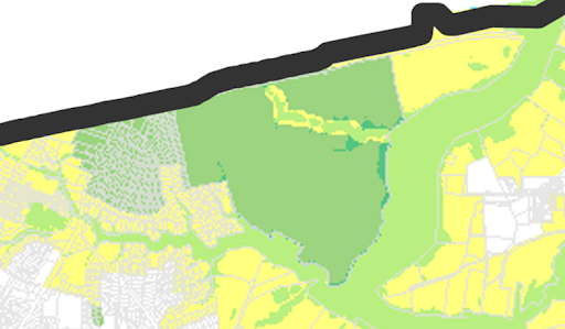
1. Fernwood Farms forested wetlands
This continues to be one of our areas of greatest concern. [The area of forested wetlands was part of the original CBPA district designation in 1992. In the meeting, we understood that the City has only been mapping Resource Protection Area (RPA) designation systematically using GIS tools for less than 5 years, so perhaps this area really should be in the RPA and not removed as proposed].
The DEQ Guidance Document Nontidal Wetlands Guidance on the Chesapeake Bay Preservation Area Designation and Management Regulations found at
"The Regulations provide clarity under Section 9 VAC 25-830-80(B)(5), which notes that the 100-foot buffer is not diminished when permitted uses, encroachments and removal of vegetation occurs. Under this subsection, post-Bay Act interruptions should not diminish the original RPA, as the RPA should be determined based on the condition of the RPA feature that existed prior to land disturbance, and the development activity should not be used to remove or diminish the RPA. Thus, where the interruption occurred subsequent to October 1, 1989, the entire wetland should be treated as an RPA feature and subject to the 100-foot buffer."
As I read this, the question becomes, would the area have been in the RPA before October 1, 1989? If so, it should still be considered an RPA. The streets Marina Reach and Pepperwood Dr. and the associated housing were built after October 1, 1989.
Also, the guidance document states that "RPAs are composed of: tidal wetlands; non-tidal wetlands connected by surface flow and contiguous to tidal wetlands or water bodies with perennial flow; tidal shores; such other lands considered necessary by the locality to protect the quality of state waters; and a 100-foot wide vegetated buffer adjacent to, and landward of, these features."
and that in
"situations where nontidal wetlands exist solely within the defined bed and bank of an intermittent or ephemeral stream, or other non-perennial conveyance. These wetlands may provide hydrologic input to the intermittent or ephemeral stream or non-perennial conveyance, or they may exist as a result of inundation due to storm events. These wetland/stream/conveyance features often exist in areas with little topographic relief, and may hold water for long periods of time given the depth to ground water of low-lying areas. These streams or conveyances may become heavily vegetated in the spring or summer months which may make onsite designation between stream and wetlands inconsistent depending on the time of year. These wetlands are not required to be included as RPA features, although they may be included as “other lands” within their local ordinance at the
discretion of a local government provided they do so consistent with Section 9 VAC 25-830-80(4) of the Regulations."
Even today, the forest wetlands at Fernwood Farm, although surrounded by houses and roads do not exist in isolation. During a storm event all the water that falls on these 90 acres does not stay solely within the confines of these 90 acres. Considering the already problematic state of Fernwood Farms and Riverwalk with regards to flooding, any clearing of the forested wetlands will make these problems worse. And if the land were developed in the future, there would be a significant increase in runoff from the area which would inevitably result in a negative impact to the water quality of state waters due to increase run-off of sediment, nitrogen, and phosphorus; no practical BMP system works as well as 100% forest cover, nor would it be required to. So, even if this land were not required to be part of the RPA as the Interrupted Wetlands I believe it is, the City should use its discretion to include it as "other lands" to be in the RPA.
Area designated for removal in red
National Wetlands Inventory
Google Earth 4/8/1990
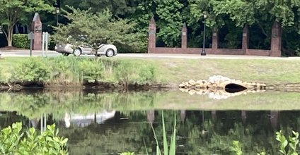
2. Storm pond and forested wetlands just north of Riverwalk Parkway [at north end of Creek Lane]
[We asked the City to] provide documentation on the elevation of the stormwater conveyance from the pond on Riverwalk Parkway to its outfall. It is hard to see that this pond routinely dries out so as to leave the pond below the infall. Also, I noted that the pond is rimmed with Baccharis halimifolia, i.e. salt bush.
Pond on Riverwalk Parkway
Baccharis halimifolia
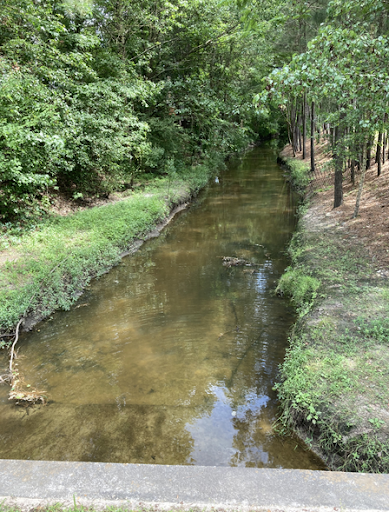
4. A long stretch of drainage in the Pines of Warrick in Great Bridge [south of Cedar Road]
[We asked the City to] provide documentation on the determination that this is an intermittent stream. The stream upstream of Middle Oaks Drive is substantial, 10' to 12' wide, and considering it drains about 400 acres and is fed by two storm ponds, I wouldn't expect it to dry out during normal rainfall conditions.
Area designated for removal in red
Stream at Middle Oaks Drive
5. A section in Western Branch off Gum Road (Amelia Estates)
At least 3 additional parcels (marked with red lines on the images below) appear to be within 100 feet of the perennial stream to the east of the curve on Gum Road, that should be in the RPA. Also, the stream valley to the west of the road does look quite healthy in this 2020 aerial and [we asked the City to] consider using its discretion to continue to protect this land west of Gum Road in the RPA, even if the stream is found to be intermittent.
Area designed for removal in red
6. Commercial block off Western Branch Blvd, east of Popular Hill Rd in Western Branch
During the meeting it was stated that the streams and wetlands in this area are cutoff by the old railroad line. But I went and walked the right-of-way - now the new Western Branch Rail Trail - and the area to the west of the trail are connected to the stream to the east by a level culvert under the Rail Trail, located about 200 yards to the northeast of where Popular Hill Road crosses the trail. The perennial stream running to Popular Hill Road and wetlands extending up to Washland on Portsmouth Blvd are not isolated from the stream to the east. [I believe] these should be in the RPA.
Areas designated for removal in red
Culvert under Rail Trail
7. A section of forested wetlands in Joliff Woods - parcel 0150000000060
[We asked the City to] to check on an existing determinations.
Forested wetlands adjacent to existing CBPA area
8. Forested wetlands west of I-664 that are not in CBPA, but maybe should be
[We asked the City to] check whether the stream under I-664 that flows between the warehouses and the forested wetlands is perennial.
9. Brentwood neighborhood west of St. Juliens Annex
[We asked the City to] to re-look at addition [to be consistent with other areas that are being removed].
Area to be added in darker greens
10*. Parcel on Indian River headwaters between Paramont Avenue and I-64 -
[We asked the City to] look adding parcels immediately south of Indian River Road - 0200000000064 and 0200000000061 - to CBPA - the perennial stream continues through culvert under Paramont Avenue
Also, the perennial stream continued through a culvert under I-64, therefore a portion of parcel 0280000000045, which has forested wetlands should also be considered part of the RPA.
National Wetlands Inventory
11*. Lake/Pond at Indian River High School and behind Parkview Shopping Center
I note that on the current CBPA District Map in the City system, the lakes and stream on this central tributary of the Indian River are marked as being the in the CBPA District. These are NOT shown as in the CBPA District in your proposed maps.
[I believe] these should be RPA's per "Determinations of Water Bodies with Perennial Flow, Guidance on the Chesapeake Bay Preservation Area, Designation and Management Regulations, September 2003; Revised December 10, 2007 and June 21, 2010"
The Resource Protection Area includes ponds, lakes, or other impoundments with perennial streams flowing either into or out of them with exceptions as noted below. Impoundments (lakes and ponds) developed as stormwater management facilities to address stormwater quality and/or quantity requirements may be required to be designated as RPAs. If the size of the impoundment exceeds that which is necessary to provide flood control, stormwater water quality treatment or both, then they should be considered amenities and treated as RPA features. In order for existing stormwater management facilities to be exempted from inclusion as a required RPA feature, they must have been designed and installed in accordance with the locality's standards for stormwater management facilities in effect at the time of plan approval. In order for new stormwater management facilities to be exempt from inclusion as a required RPA feature, they must meet all of the criteria outlined under Section 9 VAC 10-20-130 1 e of the Regulations"
The lake by the high school is an old borrow pit from the 1960's and was not designed specifically designed as a stormwater facility.


.png)